Your true Icelandic winter adventure awaits. Book your tour now!

Thingvellir National Park (Þingvellir) is one of the best geological wonders in Iceland. This UNESCO World Heritage Site and Game of Thrones filming location is just a 45-minute drive from Reykjavík. Traverse the epic Icelandic landscape where the North American and Eurasian tectonic plates meet!


What to See in Thingvellir National Park

This is one of those spots in Iceland that’s hard to miss when you’re doing any research on the country. It’s a top recommendation for a reason. The park's one-of-a-kind terrain and heritage make it a highlight of the Golden Circle day tours.


Thingvellir national park in summer vast landscape with green trees and blue skies

Þingvellir National Park in summer. Source: Arctic Adventures.

The National Park is unique because it has been shaped by volcanic activity and tectonic movement. Here you can explore deep fissures, clear lakes, and impressive rock formations. You'll also discover historic sites associated with Iceland's early settlers. Some of the main places to visit in the area are:

Silfra Fissure: The only place where you can see a continental rift underwater, this water-filled rift in Iceland is a diving and snorkeling paradise. Swimming and seeing the gap in the Earth’s crust is a mesmerizing moment you’ll remember forever!

Öxarárfoss Waterfall: Rivaling the beauty of South Coast waterfalls, Öxarárfoss cascades from the edge of Almannagjá Gorge. Nicknamed the “Axe River Waterfall,” it’s a sight that you will most certainly want to visit.

Almannagjá Gorge: A path between two tectonic plates, the gorge is well-known for its geological uniqueness. You can venture into the rift that has expanded between the Eurasian and North American plates, even standing between them.

Lögberg (The Law Rock): This rock is of historical importance. It’s the location where the Icelandic parliament, Althing, met and discussed important issues. Politicians spoke their ideas and raised questions to the crowds below.

Þingvellir Church: Built around 1000 A.D., this church is one of the oldest buildings in Iceland. Picturesque, you can see it inside and out and even visit a cemetery where Icelandic poets are buried.

Thingvellir Lake: A jewel of the park, this lake is the biggest in the area. Due to its remoteness and isolation from other water sources, the plants and fish species here have evolved to be some of the most unique in the world.

Þingvellir Hiking Trails: Hiking through the park is a must. It’s a fun and exciting way to experience the area's beauty, and thanks to the marked trail, you’ll see the main highlights in one go!

Drekkingarhylur Pond: The lake has a dark history as a place where people were executed. Because of its historical significance, swimming is not permitted. However, you can still admire the beautiful scenery around it.

Peningagjá Pond: This small, scenic pond is known for its charming folklore, which claims that any coins tossed into it will come back to the thrower.


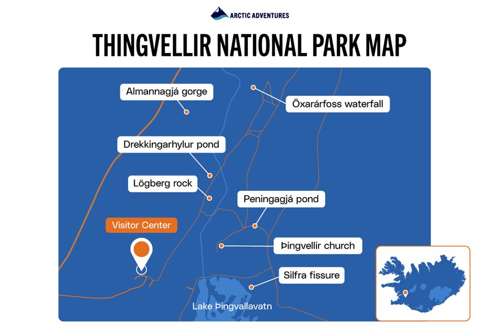
Thingvellir National Park Map


Thingvellir is a large park connected by well-maintained paths. Sights are scattered throughout the area. The Park’s Visitor Center is located near the P1 parking lot.  

If you go east from the visitor center, you'll find Silfra fissure. Going north, there's a bridge that crosses the Peningagjá fissure. Going straight from the center will take you to Þingvellir Church.

If you go through the Almannagjá canyon, you'll be surrounded by continental plates. Past Snorri's Booth, a landmark related to the Icelandic poet and historian, you'll find the supposed location of The Law Rock. A few more steps to the right and you'll see Drekkingarhylur pond.

In both cases, if you continue north, you'll reach the narrow path that leads to Öxarárfoss waterfall.


Thingvellir National Park: Things To Do

At Thingvellir, you can interact with exhibits and join guided walks. Stroll through the gap between tectonic plates, or try Silfra snorkeling in crystal-clear water.

The park is popular with fishing enthusiasts, and you can also enjoy horseback riding. Follow the marked trails or simply relax by the biggest lake in Iceland and take in the scenery. Below, we compiled a list of activities you can do during your visit.


Walk Between the North American and Eurasian Continents

Thingvellir walking path between tectonic plates in winter

The path between Iceland’s 2 continents. Source: Arctic Adventures.

Few places in the world offer such a clear and accessible way to walk between tectonic plates. This unique experience takes place in Almannagjá Gorge, a prominent feature of the Thingvellir rift. Here, the North American and Eurasian plates meet and slowly drift apart.

The starting point of the hike is the viewing platform Hakið on the North American plate. From here, you can see the continental rift below, with Thingvellir Lake (Þingvallavatn) in the distance and the Eurasian plate across the valley.

After enjoying the view, stroll through the Almannagjá Canyon to physically cross the space between the continents and experience the geological boundary up close.


Snorkel in Iceland’s Continental Divide

Snorkeling tour group walking into deep blue water between two continents divided

Diving and snorkeling in Silfra. Source: Arctic Adventures.

The Silfra fissure in Thingvellir National Park is right in the cut where two continental plates meet. It formed relatively recently in an earthquake and quickly filled up with water that had been filtering through the lava field for hundreds of years.

The water that initially comes from Langjökull glacier is extremely clear. Many say that divers' visibility is the best in the world.

Snorkeling in this Icelandic rift and diving tours in the fissure are some of the best activities you may experience in the þingvellir. We provide suitable dry suits so you can stay warm in the glacial waters.

Silfra Fissure is often called the visibility wonderland, and floating between the North American and Eurasian continents feels like looking right into the earth's core. It is entirely incomparable and truly inspiring!

Silfra Snorkeling Combo Tours

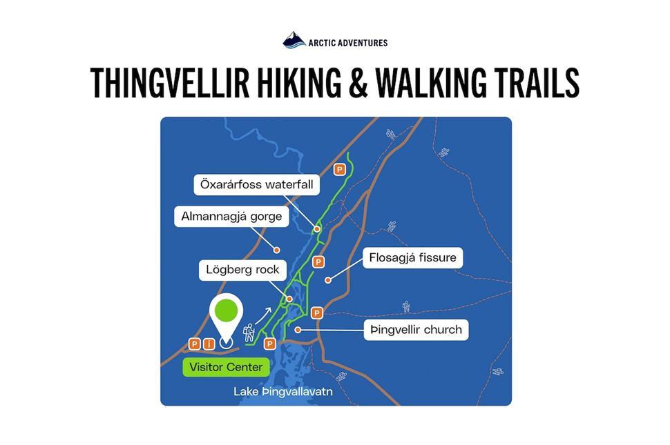
Explore Thingvellir National Park Hikes

The main hiking trail is a loop starting at the Visitor Center. This route takes you through the Icelandic Rift Valley between the plate boundaries. Highlights along the way include Lögberg (Law Rock), Öxarárfoss Waterfall, Almannagjá, Thingvellir Church, and the Flosagjá fissure.


Wide walking route inside thingvellir national park

Park's hiking trail. Source: Arctic Adventures.

Additional walking and hiking trails are also available. However, smaller paths might be less maintained than the main route. Some lead to the campsites or the Skógarkot farm ruins.

Wear sturdy boots, especially in winter, and avoid wearing sneakers or heels. It is also prohibited to fly drones in the park.


Enjoy Fishing in Lake Thingvellir (Þingvallavatn)

Admire the scenery of Lake Thingvellir with a fishing rod in your hands. Large ice-age brown trout and four types of Arctic char swim in these waters.

The fish in Iceland’s largest natural lake - Þingvallavatn, have evolved for about 10,000 years since the last Ice Age. The constant flow of groundwater and diverse habitats help these species thrive.

Fishermen from around the world come to Thingvellir Lake, particularly for the brown trout, which can weigh up to 30 pounds (about 13.6 kilos)! The best time to catch them is from April to early June.

According to the park’s angling regulations, the lake's angling license costs 2,500 ISK (approximately $18.10) for a single day or 9,900 ISK (around $71.67) for the entire season—from April 20th to September 15th. Additionally, if you catch a brown trout, it must be released.

But the fun doesn’t stop here. Angling is just one of 8 things you can do in Þingvellir Park. Find even more activities waiting for you.

Popular Thingvellir Park Tours

Þingvellir in Detail: The Iconic Rift Valley in Iceland

Rocky walls with the route of the park in between where a group of people is walking in the distance

Thingvellir - on the tectonic plate boundaries of the Mid-Atlantic Ridge.

True beauty takes time to develop, and this UNESCO World Heritage Site is a perfect example. The famous Rift Valley, one of the five National Parks in Iceland, took thousands of years to form and even longer to become a global landmark.

It is unimaginable to leave Iceland without going here. Especially because þingvellir National Park is a part of Iceland’s Golden Circle route. We will explain why this area is so important through its history and geology.


Geology

Þingvellir is a remarkable geological site where you can see the separation of the tectonic plates: Eurasian and North American. It is one of the few places on Earth where this movement can be seen on land.

The Mid-Atlantic Rift or Ridge, which runs through Iceland, marks the boundary between the two plates. The park lies in a rift valley, where the Earth's crust is pulled apart. Volcanic eruptions about 10,000 years ago, after the last Ice Age, shaped the rugged terrain of Þingvellir.

As the tectonic plates slowly drift apart, they create a widening gap in the landscape. This crack expands by about 2 cm (0.78 inches) every year. A visit to this park allows you to observe this ongoing geological process up close.


History

Translating Þingvellir to English means "Assembly Plains." For Icelanders, the park holds great historical significance. Many consider it the birthplace of the nation. Althingi, the oldest parliament in the world, was established here in 930 AD.

For over 800 years, Icelandic lawmakers gathered at Lögberg (Law Rock) to pass legislation and make speeches until 1798. In 1000 AD, Iceland peacefully converted to Christianity here, while still allowing private worship of Norse gods.

In 1928, Icelandic law officially recognized Thingvellir as a national park to mark the millennium of Alþingi. Later, in 2004, UNESCO declared the park a World Heritage Site in honor of its significance.


Facilities

There are two camping areas at Thingvellir -  Leirar near the Visitor Center and Vatnskot by Lake Þingvallavatn. The visitor center has a paid interactive exhibition to engage with the park's story in an educational way.

Parking is available at five locations within the park, with fees ranging from 1,000 ISK or approximately 7.2 USD. The park itself has no general entrance fee and is open year-round, 24 hours a day.


Thingvellir National Park Game of Thrones

Frozen waterfall in thingvellir from ariel view with tourists exploring

Oxararfoss Trail was used as a filming location in the TV series Game of Thrones.

The most popular fantasy series in the world, Game of Thrones, was filmed here multiple times. The park was used as a backdrop for the Vale of Arryn, a region from the show and books. This area, part of the Seven Kingdoms, is depicted as a rocky, mountainous region with steep cliffs and narrow paths.

The show featured Thingvellir and its surrounding landmarks in several key scenes.

Öxarárfoss Trail appears in season 4, episodes 5 and 8. The Bloody Gate, shown as a narrow passage along this trail, is where Arya and the Hound travel on their way to the fortress of Eyrie.

Nesjavellir Geothermal Area was a set for the Hound and Brienne of Tarth sword fight in the finale of season 4. It was also used in a backdrop shot when Arya left Westeros for Braavos.

Thorufoss Waterfall represented a location in Essos. In season 4, episode 6, a dragon flew up this waterfall and burned down a flock of sheep.

The island's connection to the show doesn’t end at Thingvellir. Our detailed traveler guide explains all of the Game of Thrones Iceland filming locations in more depth.

Game of Thrones tour

Main Highlights of Thingvellir Park

The main highlight of this Icelandic national park is its geological features. However, you don’t need to be a scientist or archaeologist to appreciate it. You can learn about Icelandic customs and ancient history while enjoying the park’s sensational landscapes.


Icelandic Rift of Silfra
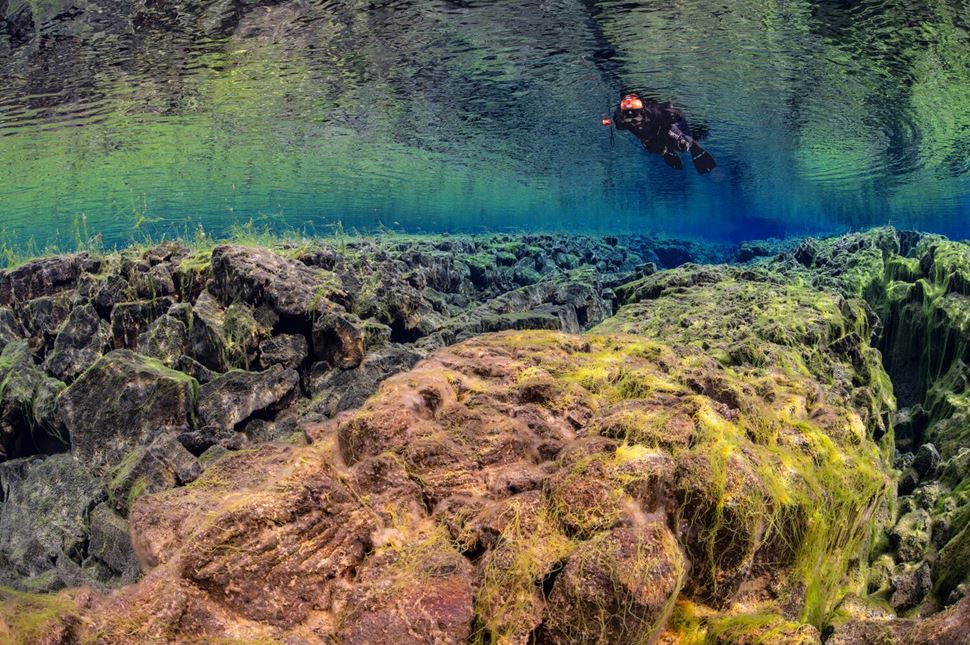
Person snorkeling above mossy tectonic plates

Underwater view of Silfra Fissure, where crystal-clear waters reveal the divide between two tectonic plates. Source: Arctic Adventures

Silfra is a fissure or crack created by earthquakes caused by the movement of the North American and Eurasian plates. Formed in 1789, its clear glacier water is supplied by the nearby Langjökull.

It takes years for the glacial meltwater to filter out and come out from the spring under the formation. This is why the Rift is one of the world’s best diving and snorkeling spots.

Due to its location, people can view the tectonic rift underwater. The water never freezes, so divers and snorkelers can enjoy the sight year-round.


Öxarárfoss Waterfall
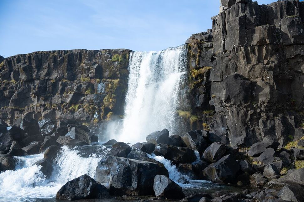
Waterfall flowing over rocky mountain cliff at Thingvellir

Öxarárfoss Waterfall tumbling over rocks in Þingvellir National Park.

The impressive waterfall flows off the edge of Almannagjá Gorge and creates a cascade that is 44 feet (13 meters) tall. It is located in the National Park and is easily accessible via the main hiking trail.

The Öxarárfoss waterfall is fed by the Öxará River, which originates from the nearby Þingvallavatn Lake. It also was a gathering place for early Icelandic settlers during the Alþingi, the country’s first parliament. Its stunning scenery is even featured in the Game of Thrones series.


Almannagja Gorge

The Path of Thingvellir Rift Valley - Almannagja is a gorge like no other in the world. Formed thousands of years ago, continental plates surround it on both sides. Due to their movement, it grows yearly. Stretching 4.9 miles (8 kilometers), it’s one of the most visited parts of the National Park. Walking through this rift feels like exploring the depths of Earth itself. You’ll have to pass through it to get to other significant sights.


Lögberg (The Law Rock)
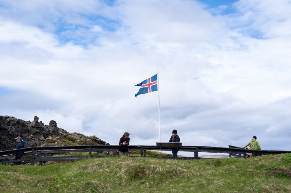
3 tourists reading and enjoying sites at Thingvellir park, standing by Icelandic flag

The Alþing site is where Iceland’s first parliament was established. Source: Arctic Adventures.

Lögberg (The Law Rock) is marked by a flag and served as the heart of the Alþing, Iceland's national assembly, from 930 to 1262. The Law Speaker, or Chief Goði, stood here to proclaim the law. Lawmakers had to stand on this rock to raise important questions, report news, and confirm the calendar. Elected by the Lögrétta (Legislative Assembly) for a three-year term, the Law Speaker was the only paid official. You can stand in the spot where history was made and have a magical photo opportunity!


Thingvellir Church
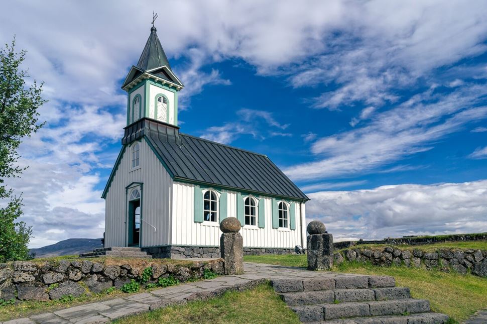
Thingvellir white traditional church in summer with light blue trim

Þingvallakirkja church is located on the national park’s walking path.

As Iceland saw more settlers come to its shores, Christianity slowly started to sip into the island. In 1000 A.D., it was eventually declared the official religion. For this reason, Thingvellir Church was built in the 11th century. Today, you can step back into history and tour the church yourself. It is one of the oldest buildings in Iceland (older than the National Park status of þingvellir).


Lake Thingvellir
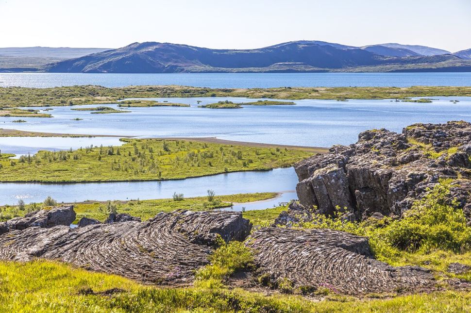
Natural lake in Thingvellir with islands of green grass and cliffs surrounding

Þingvallavatn is the largest natural lake in Iceland.

Lake Þingvellir is a unique place because it is cut off from other water sources, allowing the marine life to evolve on its own. Despite the cold temperatures, the lake is very fertile and has a lot of plant life. One-third of the bottom is covered in vegetation and plenty of algae. 

You can explore the area around the lake on foot. In the summer, you can buy a fishing license to catch ice-age brown trout, for which the lake is famous. The water doesn’t freeze and stays around 37.4 and 41 °F (3 to 4°C).


Drekkingarhylur Pool

Drekkingarhylur is a beautiful pond situated near the Öxará River. It's a picturesque view with a gruesome history behind it. Known as the Drowning Pool, from the 16th century till 1739, it was a spot of multiple drownings of women. They were executed for various crimes, like adultery and even perjury. 

Today, Drekkingarhylur is a landmark known for its beauty. Due to its history, we suggest not swimming in the water. Instead, enjoy the quiet atmosphere that surrounds the area.


Peningagjá Pond

The Peningagjá pond is part of the larger crack. It is nicknamed the "Money Fault" because people have been throwing coins into it from the bridge above it for many years. You can see the metal reflected in the clear glacial water. While the authorities have banned coin tossing, no one is stopping you from enjoying the panoramic views from the Coin Fissure. A few steps away, you'll find Thingvellir Church.


Thingvellir National Park in Winter
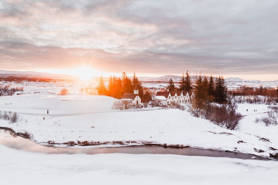
Thingvellir church and houses during winter at sunset

Thingvellir is a popular destination even in winter. Source: Arctic Adventures

Þingvellir National Park remains open and accessible throughout the winter. Most visitors can use a standard rental car with winter tires to reach the park. However, for better safety and comfort, a 4WD vehicle is recommended. Additionally, only the main walking trail has daily maintenance during winter. 

Despite the cold, tourists still come to this unique continental divide. The park is near Reykjavík but far enough to make it an ideal spot for viewing the Northern Lights. If conditions are right, you’ll be treated to a colorful dance of aurora right between the tectonic plates. It's a magical experience!


Accommodation and Hotels near Thingvellir National Park

The area around the park offers several accommodation options. If camping is not your style, you can always stay at hotels, hostels, and a variety of cabins.

Hotels

Hostels

Cabins and Cottages

  • Thingvellir Lake Cottage
  • Minniborgir Cottages and Restaurant
  • Eyvindartunga Farm Cottage
  • Austurey Cottages

FAQs

The Þingvellir rift valley formed at the boundary where the North American and Eurasian tectonic plates are pulling apart. This is why it is one of the few places where the Mid-Atlantic Ridge is visible on land.

Thingvellir is located about 27.7 miles (44.6 kilometers) away from Reykjavík, in an active volcanic area, right on a continental rift. It’s part of the Golden Circle Route and is a first stop.

You can get to the Thingvellir National Park from Reykjavik by car. Drive north on Ring Road (Road 1) for about 10.5 miles (17 kilometers). Turn onto Road 36 at the Mosfellsbær roundabout and continue for roughly 18.6 miles (30 kilometers) to the parking area. There isn't a direct bus to the park, so you'll need to drive or take a taxi. It takes around 45 minutes to reach the parking lot near the visitor center by car.

You can expect to spend about two hours exploring Þingvellir if you're just sightseeing. If you decide to hike the trails, you might want to add a few more hours to your visit. Snorkeling or diving can also extend your time, as it usually takes around two hours to experience it fully.

Þingvellir National Park is open 24 hours a day, all year round, and entrance is free. However, the visitor center has specific hours that vary throughout the year. From May to October, the center is open from 9 AM to 6 PM, and from November to May, it operates from 9 AM to 5 PM.

There are four parking lots available for visitors at the park. P1 is near the Visitor Center at the upper end of Almannagjá Gorge, while P2 is located by Öxarárfoss along the Efrivallavegur road (362). P3 is situated north of Öxarárfoss, close to Þingvallavegur road (36), and P5 is near the Silfra Fissure and Þingvellir Church.

You can pay for parking online or at the payment machines located at the Visitor Center, the restroom building, and P2 and P5 parking lots. The fee is 1000 ISK (about 7.23 USD) for passenger cars with 5 or fewer seats. For cars with 6 to 9 seats, it’s 1200 ISK (around 8.68 USD).


It is not really possible to see the Iceland plates move with the naked eye. The continental plates are separating very slowly apart, only about 0.78 in (2 cm) per year. This means you won't see noticeable movement during a single visit. However, if you visit several years apart, you might spot the difference! The gradual shift has been significant over the decades, so keep that in mind.

You can visit the park independently by taking our 3-day self-drive adventure. You’ll see the entirety of the Golden Circle and drive through the South Coast, visiting glaciers and volcanoes.

Reserve a seat on our classic Golden Circle tour to visit the park with an expert guide. They will explain the significance of the location and lead you through the major areas. If you want a more leisurely ending to your journey, we also offer a visit to the Secret Lagoon.

For a more tailored experience, our private Golden Circle excursion is the way to go. From accommodations near the park to snorkeling in Silfa, we can book everything you need for an epic time.

The correct pronunciation of Þingvellir sounds like “Th-ing-vet-lir” or {ˈθɪŋˌvɛtlɪr}.

Þ, known as the long P, is pronounced as “Th,” like in the word “thing.”

Ing pronouncement stays the same in the English language.

Vellir is pronounced as vet-lir.

In Icelandic, it is spelled “Þingvellir”. When writing the name in English, “Thingvellir” is the correct spelling. While popular, Pingvellir (P instead of T or Þ) is a more informal way of anglicizing the name.