Every night could be the night for the aurora. Let’s Hunt
Laugavegur Trail is Iceland’s most popular multi-day trek through the rugged landscape of the Highlands region. The hut-to-hut hiking route stretches between Landmannalaugar and Þórsmörk for 55 km (34 mi) and takes 3 to 4 days to complete. Each section is marked by contrasting sights, like colorful rhyolite mountains, black sand deserts, forests, and glacier valleys. This trail is one of the most beautiful hikes in the world, even recognized by National Geographic.
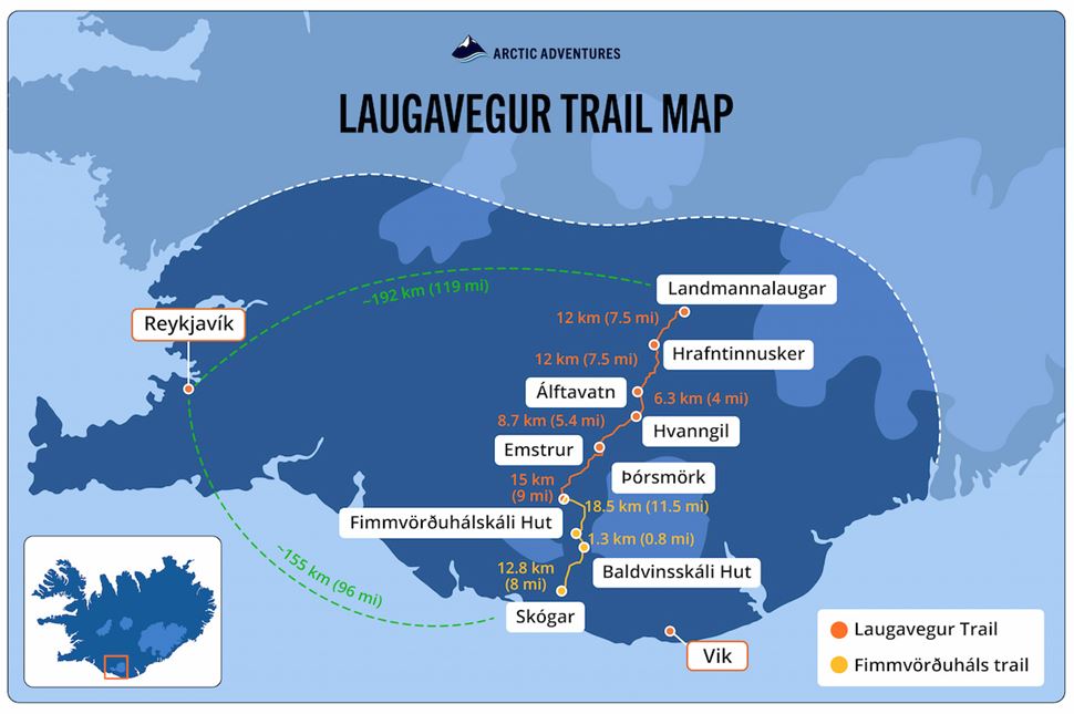
Map of Laugavegur Trail, Iceland. Source: Arctic Adventures.
The Laugavegur trail is located in the uninhabited Icelandic Highlands, stretching 55 km (34 mi) southward. It begins in Landmannalaugar’s hot springs and climbs over Hrafntinnusker’s windswept plateaus. From there, the route descends past Álftavatn and Hvanngil’s remote river plains, crosses Emstrur’s barren volcanic deserts, and ends in Þórsmörk’s birch forests. There are no paved roads or settlements along the route—only mountain huts and designated campsites. Hikers can extend the trek 25 km (15 mi) with the Fimmvörðuháls trail, crossing between glaciers before descending to Skógar’s coastal lowlands. The trail is only open in summer, accessible by special buses and 4x4 vehicles from Reykjavik.
Commonly known as one of the most scenic Iceland hiking trails, the Laugavegur trek is divided into four sections over four to five days. It begins in steaming geothermal terrain, followed by the longest section through glacial valleys and volcanic peaks. Next comes a stretch of black deserts carved by rivers before the final descent into lush birch forests, completing this backpacking adventure in Iceland.
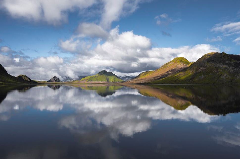
Views on the Laugavegur hike. Image courtesy of Gunnar Gaukur Guthmundsson.
Distance: 55 km (34 mi)
Time: 4 days
Total Ascent: ~1,500 m (~4,920 ft)
Highest Point: 1,060 m (3,474 ft) at Hrafntinnusker
The hiking passage is a well-marked, multi-day trail through Iceland’s Southern Highlands. The Laugavegur Trek Iceland is known for combining raw nature with challenging terrain, following wooden posts along a well-worn path. The route is logistically straightforward but physically demanding, with exposed sections, steep climbs, and river crossings. The pathway begins in the Landmannalaugar mountains, a part of a larger Fjallabak Nature Reserve. Steaming hot springs and colorful rhyolite mountains set the stage. The first section climbs toward Hrafntinnusker, the hike's highest and often coldest part of the journey. From there, the trail descends into Þórsmörk, where the highlands give way to sheltered forests.
Distance: 12 km (7.5 mi)
Ascent: 427 m (1,400 ft)
Time: 3 to 4 hours
The first part is considered the most challenging, with continuous ascents and descents. The trek begins at Landmannalaugar Hut, a base for tours and a popular stop for day hikers exploring the Fjallabak Nature Reserve. Expect to see more people here before the crowd thins out further along the trail. The first day’s route passes Brennisteinsalda mountain’s colorful slopes, crosses the Laugahraun lava field, and descends into Stórihver’s steaming vents and mud pools. The final climb leads to Hrafntinnusker Hut, surrounded by black obsidian fields and sweeping mountain views. Snow often lingers here into summer, making it one of the coldest sections.
Distance: 12 km (7.5 mi)
Descent: 490 m (1,610 ft)
Time: 4 to 5 hours
The second part of the route is of moderate difficulty, taking hikers from Hrafntinnusker’s barren, windswept plateau into greener landscapes. You’ll walk through small ravines, often holding snow even in summer, before reaching the Jökultungur hills, where deep valleys open below. A steep descent leads you to Grashagakvísl, a river cutting through a mossy oasis. From here, the scenery shifts dramatically—dark volcanic terrain gives way to the Álftavatn lake, where glacial water reflects towering peaks. While Álftavatn hut is the first major accommodation with a campsite, some hikers opt to stay overnight in Hrafntinnusker’s small hut before continuing. Fog and strong winds are frequent in this stretch.
Distance: 16 km (10 mi)
Descent: 60 m (200 ft)
Time: 6 to 7 hours
The third part of the trail features multiple river crossings, starting right near the hut with the Bratthálskvísl river. From there, climbing the green Brattháls ridge takes you to Hvanngil Hut, a good alternative to staying at Álftavatn for those who walk more on the previous day. After crossing the Kaldaklofskvísl river by footbridge, you'll encounter Bláfjallakvísl, a glacial river that must be crossed on foot. The final crossing, Innri Emstruá, is with a bridge. As you continue, the lush landscapes quickly give way to the obsidian dark sands of the Mælifellssandur desert. The section ends at Emstrur Hut, near the dramatic 200 m (656 ft) deep Markarfljótsgljúfur canyon.
Distance: 15 km (9 mi)
Descent: 228 m (750 ft)
Time: 6 to 7 hours
The final leg of the journey, Thórsmörk hike, begins with volcanic landscapes and a steep descent. A wooden bridge spans the canyon, leading to a plateau where the Syðri-Emstruá and Markarfljót rivers carve through the highlands. The trail winds through the Almenningar area, passing Slyppugil and Bjórgil ravines, where clear streams provide fresh drinking water. As you progress, the increasing greenery signals the approach to Þórsmörk nature reserve. A footbridge over Ljósá is followed by a final climb over Kápa hill before descending to Þröngá, the last river crossing. The trail ends in the lush Thórsmörk valley, where the Básar hut rests at the foot of Eyjafjallajökull glacier—marking the final stretch of the legendary Laugavegur trail, featured in our 5-day trek and South Coast tour.
Distance: 25 km (15.5 mi)
Ascent: ~1,000 m (3,280 ft)
Time: 8 to 10 hours
The Laugavegur and Fimmvörðuháls trail combo is a legendary multi-day route connecting Iceland’s highlands to the South Coast. From Þórsmörk, the trail climbs steeply through volcanic terrain to Fimmvörðuháls hike, where you can see the craters Magni and Móði, formed by the 2010 Eyjafjallajökull eruption. A hut at the summit is a resting point before descending toward the Skógá River. This section is famous for its series of over 20 waterfalls, culminating in the iconic Skógafoss. The trail ends in Skógar, a small village with a campsite and guesthouses, marking the official end of this epic trek from the highlands to the coast.
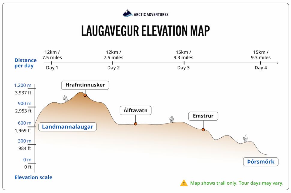
Laugavegur Trail elevation. Source: Arctic Adventures.
The Laugavegur Trail starts at 600 m (1,968 ft) in Landmannalaugar, climbing to its highest point at 1,141 m (3,743 ft) in Hrafntinnusker. It then descends to 537 m (1,761 ft) at Álftavatn and continues dropping to 465 m (1,525 ft) at Emstrur. The final stretch leads downhill to 200 m (656 ft) in Þórsmörk.
The Laugavegur hiking trail is packed with unforgettable sights, from lava fields to immense glaciers and deep canyons. Hikers pass through steaming geothermal areas, black sand deserts, and glacial rivers, experiencing some of Iceland’s most diverse landscapes. Hikes near hot springs make Landmannalaugar a spectacular starting point.
Landmannalaugar: A geothermal wonder in the heart of the Icelandic Highlands. It is renowned for its numerous swimmable hot springs, which have earned it the affectionate nickname “the People’s Pools.” The area is dominated by rhyolite mountains, their slopes painted naturally in striking shades of red, pink, and green.
Hrafntinnusker: A dramatic mountain sitting atop a volcanic system, unlikely to erupt anytime soon. Named after the obsidian rocks that coat the land in deep black, its stark contrast of colors and textures is truly breathtaking. Icelanders used the volcanic rock from the surrounding lava fields to build structures like the National Theatre in Reykjavík.
Álftavatn: Translating to "Swan Lake," Álftavatn is a scenic body of water on the trail, surrounded by green hills and volcanic terrain. Named after the whooper swans that visit, it also attracts ducks and other birds. A large hut is located nearby, and shallow rivers—easily forded on foot—separate it from the rest of the Highlands. This is one of several well-maintained huts in Iceland used by hikers along the Laugavegur trail.
Hvanngil: A valley nestled between moss-covered hills and volcanic ridges, acting as a shelter from strong highland winds. The hut and campsite sit beside a small river crossing near an old sheep enclosure. Surrounded by black sand plains and hardened lava formations, this valley marks the transition into harsher, more exposed terrain.
Emstrur: A highlands desert region surrounded by black sand plains and steep ravines. Markarfljótsgljúfur Canyon, plunging 200 m (656 ft), dominates the landscape. Snow-capped peaks of Mýrdalsjökull glacier rise in the distance, contrasting against the barren terrain. Patches of moss and wildflowers soften the volcanic desolation, creating an otherworldly scene.
Þórsmörk: A nature reserve nudged between Tindfjallajökull, Mýrdalsjökull, and Eyjafjallajökull glaciers. The “Valley of Thor” name comes from the landscape of green moss patches, black volcanic sands, and woods—a lush paradise allegedly crafted by a Nordic God. The panoramic mountain views from the surrounding ridges complete this stunning landscape—and for those eager to keep exploring, the journey continues beyond Þórsmörk on the 8-day Grand Laugavegur Trek and Iceland’s Highlights tour, featuring Fimmvörðuháls, the South Coast, and more of Iceland’s natural marvels.
Fimmvörðuháls: A dramatic mountain pass nestled between the Eyjafjallajökull and Mýrdalsjökull glaciers. In 2010, the Eyjafjallajökull eruption tore open a 500-meter (1,640-foot) fissure, spewing lava and ash. The event reshaped the landscape, creating two craters, Magni and Móði, named after Thor’s sons in Norse mythology. Today, the area showcases fresh volcanic terrain, a stark reminder of Iceland’s ever-changing geology.
Skógar: A charming village at the end of the Fimmvörðuháls trek. The path leading to Þórsmörk is dotted with waterfalls, with the biggest one being Skógafoss at 60 m (196 ft). Skogar Museum, composed of six historical buildings, holds around 18 artifacts of cultural importance to Icelanders. Route 1 goes right on the edge of the town, connecting it to Reykjavík and other attractions, like Sólheimajökull Glacier.
The Laugavegur trail length is 55 kilometers (34 miles), extending up to ~78 kilometers (48 miles) if you reach Skogar via Fimmvörðuháls extension. Hiking the Laugavegur trail takes 3 to 4 days to complete for an average hiker, with an additional day if you include traveling through the mountain pass.
The trek's difficulty is considered moderate to challenging due to the many elevation changes and river crossings. While not highly technical, it is physically demanding. Expect steep ascents and descents, vast open plains, and unpredictable Icelandic weather—significantly harsher in the Highlands. To add to the challenge, trekkers must carry a backpack of essentials for the entire journey.
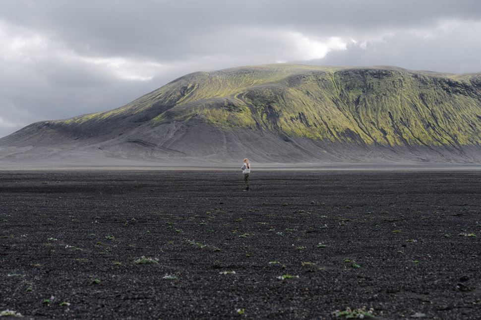
Summer is a prime hiking season on the Laugavegur Trail. Source: Arctic Adventures.
Icelandic Highlands are accessible from late June to early September when temperatures average 5–12°C (41–54°F) during the day and 1–5°C (34–41°F) at night. Snow tends to stick to mountainous areas, but strong winds and rainfall are frequent throughout the route. The hiking season coincides with the Midnight Sun, giving you nearly 24 hours of daylight to explore.
From late fall to early spring, temperatures drop below -5°C (23°F). Harsher weather conditions increase the risk of isolation and hypothermia. Laugavegur huts close down as the massive snowfall on the paths makes them inaccessible. Due to the difficult Landmannalaugar weather in winter, Laugavegur trail-guided treks and self-guided adventures are conducted only in the summer.
Given the Laugavegur Trail's challenging weather and remote terrain, deciding between solo hiking and a guided tour depends on your experience, planning, and comfort with unpredictable conditions. A Laugavegur trail self-guided hike offers independence and flexibility but requires careful preparation and self-sufficiency, especially in tough Icelandic weather. A guided tour, on the other hand, provides expert support, safety, and logistics, allowing you to focus on the experience. Both options come with their own set of advantages and challenges—here’s a closer look at Solo Hiking vs. Guided Tours:
Solo Hiking
Guided Tours
Laugavegur trail huts are found along the entirety of the route and provide two forms of accommodations: indoor spaces and camping in tents. The cost to reserve a spot at Landmannalaugar, Hrafntinnusker, Álftavatn, Hvanngil, Emstrur, and Þórsmörk between May 1, 2025, and April 30, 2026, is 15,800 ISK (€107.63 / $112.63) per location. Laugavegur trail camping is slightly cheaper, costing 3,200 ISK (€21.80 / $22.84) per night (FÍ, Iceland Touring Association).
The larger huts on Laugavegur trail have running water and flush toilets, while the smaller ones require fetching water from streams and using outdoor lavatories. All huts provide drinking water, but bedding is not included—bring your own sleeping bag. Guests can use shared kitchens with gas stoves, while campers need their own cooking gear.
Some huts sell snacks, but hot meals are rare. Those who don’t stay overnight pay 700 ISK (~€4.77 / ~$5) to use toilets and outdoor grills, and showers cost 1,000 ISK (~€6.81 / ~$7) extra. These fees don’t include access to the huts or other indoor areas. All visitors must follow official hut rules—like cleaning up after themselves and respecting quiet hours.
Mountain huts: Provide shelter from the weather, have limited spots (advance booking required), offer less privacy, include kitchen and indoor toilet access, and are more expensive.
Camping sites: More affordable, offer greater privacy, but are exposed to harsh weather, require more gear, lack hut kitchen access, and make cooking more challenging.
The number one rule is to use a spacious 55 to 70-liter backpack with back support that won’t strain your back during the long journey. Next, dress in weather-appropriate layers: a quick-drying base layer, an insulating mid layer, and a waterproof, windproof outer shell to protect against rainfall and strong winds in the Highlands. Avoid jeans or cotton clothes, as they offer little protection from the strong winds and precipitation. Lastly, pack light. You'll be traveling for 3 to 4 days, so only put essentials on your Laugavegur packing list to avoid unnecessary weight.
Clothing: Waterproof and windproof jacket and pants, moisture-wicking base layers (merino wool or synthetic), insulating mid-layer (fleece or down jacket), long-sleeve moisture-wicking shirt (merino wool or synthetic), extra pairs of wool socks and underwear, gloves, hat, and buff (for warmth and wind protection).
Footwear: Sturdy, waterproof hiking boots (broken-in), sandals for river crossings, camp shoes for rest stops, and gaiters for mud and snow.
Camping gear: A lightweight tent (wind-resistant), sleeping bag (insulated for warmth), compact stove and fuel, cookware and utensils, a headlamp with extra batteries.
Food and water: High-energy, lightweight meals (dehydrated or freeze-dried), nuts, dried fruit, energy bars for snacks, a 2-liter water bottle, water filter, or purification tablets.
Navigation tools: Phone, map of Laugavegur route, GPS device, compass, personal locator beacon.
Other items: Trekking poles, microspikes, first-aid kit, multi-tool, sunglasses, swimsuit, biodegradable soap, personal toiletries, lip balm, sunscreen, plastic bags, battery backup.
With the right preparation, you’ll be fully equipped to take on one of the most unforgettable Iceland hiking trips—this iconic and legendary trek in the Highlands.
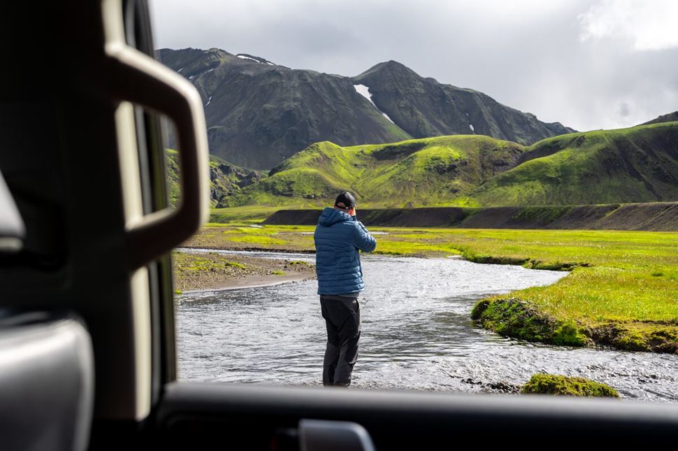
Getting to Laugavegur involves buses, 4x4s, and river crossings. Photo by Arctic Adventures.
All transportation is arranged on our guided hiking tours, so there’s no hassle getting to or from the trail. Independent travelers should note there’s no public bus from Reykjavik to Landmannalaugar. Private transfers run from Reykjavík to Landmannalaugar and from Þórsmörk—the standard endpoint of the Laugavegur Trail—back to Reykjavík during summer months. Alternatively, you can drive yourself the 192 km (119 mi) to Landmannalaugar in around three hours, but you’ll need a 4x4 vehicle due to rough F-road conditions. If you continue hiking along the Fimmvörðuháls Trail and finish at Skógar, public bus route 51 operates daily from Skógar Campsite to Reykjavík year-round.
Iceland’s weather is capricious, even in summer, so following Laugavegur hiking safety rules is a must for an enjoyable journey. Expect sudden storms, strong winds, and even freezing nights. Check the Laugavegur trail weather forecast before setting out. To find the Laugavegur area on a weather map, look for the exclamation point in southern Iceland. When the trail is open for the season, click on that exclamation point to see the latest alerts, conditions, or any road closures. This helps you stay informed and safe on your hike.
Pack layers, waterproof gear, and extra food. River crossings require caution—unbuckle your backpack, cross at the widest point, and use trekking poles for balance. If the current is too strong, turn back. Get travel insurance, and carry a GPS, map, first aid kit, and emergency shelter. Bring a waste bag to follow Leave No Trace principles—there are no trash disposal services. In an emergency, dial 112 or use an Icelandic emergency beacon, available for rent in Reykjavík.
Laugavegur in Iceland is one of the world’s most stunning hikes, with hot springs, colorful rhyolite mountains, lush valleys, and glaciers. You'll trek through deep canyons, vast lava fields, and across obsidian terrain, spending nights beneath the Midnight Sun. One moment, you’re crossing a glacial river; the next, you’re standing in silence, surrounded by steaming earth and distant ice caps. Whether chasing adventure or solitude, hiking trails in Iceland rarely match the raw beauty of Laugavegur—a journey that stays with you long after the last step.
The Laugavegur Trek is often considered the most beautiful trail in Iceland due to its stunningly diverse landscapes. This 4 day Iceland tour takes trekkers through the vibrant rhyolite mountains of Landmannalaugar to the lush, green valleys of Þórsmörk. There are various Laugavegur treks available, including the additional Fimmvörðuháls trail, which goes between Eyjafjallajökull and Mýrdalsjökull glaciers and features multiple waterfalls.
Laugavegur is a renowned 55 km (34 mi) trekking route in Iceland, stretching from Landmannalaugar to Þórsmörk. Hikers must traverse stunning geothermal landscapes, forests, glaciers, and multicolored rhyolite mountains. The trail, also known as “The Hot Springs Route,” is truly a one-of-a-kind experience.
Laugavegur trail is located in Iceland and runs downward through the Southern Highlands. The route goes through Hrafntinnusker mountain, Álftavatn lake, Markarfljótsgljúfur canyon, and Þórsmörk valley. It can also extend to the village of Skogar through the Fimmvörðuháls pass.
The Laugavegur trail treks are typically open from June to mid-September when the route is accessible and the huts are staffed. Outside this period, heavy snow and harsh weather make it impassable. The Icelandic Road Authority determines the exact opening and closing dates based on road and trail conditions.
To reach the Laugavegur trail, you can drive from Reykjavík to Landmannalaugar using a 4x4 vehicle, following Route 1 along the South Coast, then taking Road 30, Road 32, Road 26, Road 208, and finally F224. Alternatively, a daily bus from Reykjavik to Laugavegur trail is run by private tour operators during the summer months.
The Laugavegur trail is approximately 55 km (34 mi) long, going from the geothermal wonderland to the Valley of Thor. Hikers typically complete the trek in 3 to 4 days, depending on their pace and weather conditions. For those looking to extend the journey, the Fimmvörðuháls trail adds 23.7 km (14.7 mi) and an extra day, leading to the village of Skógar.
The Laugavegur Trail is considered a moderate to challenging 55 km (34 mi) multi-day hike. Trekkers will walk through volcanic deserts and lava fields and experience changes in altitudes by ascending and descending mountains and hills. The trek includes several unbridged river crossings, whose currents and depths vary with every stream.
Yes, experienced hikers can trek the Laugavegur trail without a guide during the summer. However, if you’re not a professional, you might want to use an expert when trekking this route. Guided tours ensure the navigation, hut accommodations, and transportation to and from the starting and end points, making the journey smoother and more enjoyable.
On the Laugavegur trail, you can sleep in mountain huts located at Landmannalaugar, Hrafntinnusker, Álftavatn, Hvanngil, Emstrur, and Þórsmörk, spaced for each night of the trek. Camping is a cheaper alternative, with designated tent areas near the huts, but you must bring your own gear. Both options fill up fast, so booking well in advance is essential, as they are the only accommodations available on the trail during the hiking season.
The Iceland huts along the Laugavegur trail are spaced approximately 12 km (7.5 mi) apart, with Landmannalaugar located 11.9 km (7.4 mi) from Hrafntinnusker. From Hrafntinnusker, Álftavatn is another 11.9 km (7.4 mi) away. Emstrur (Botnar) is 16 km (10 mi) further, and the final hut at Þórsmörk is 14.48 km (9 mi) away.
For the best Laugavegur hike photos, start at Landmannalaugar, where colorful rhyolite mountains contrast with steaming hot springs. Capture Hrafntinnusker’s obsidian slopes and lingering snow, then the Álftavatn lake’s calm reflections. Emstrur’s canyons add dramatic depth, while Þórsmörk’s lush valleys provide a striking finale. If continuing, Fimmvörðuháls pass offers glacier views before ending at Skógafoss waterfall.
The Laugavegur trek in winter is impassable and dangerous due to unstable weather conditions. The huts, the only accommodations along the route, are closed and inaccessible as snow often blocks the paths. Even with the proper gear, the cold temperatures and the trail’s remoteness increase the risk of hypothermia and getting lost.
Laugavegur pronunciation is broken down to Loo-ga-vey-gur syllables or [ˈluːɡaˌveɪɡʊr]. The name “Laugavegur” is made up of two different words: “lauga” for “hot spring” and "vegur" meaning “part” or “way.”
The cost of our 4-day Laugavegur hiking tour—with guides, transport, accommodation, and meals included—is 269,990 ISK (€1,838 / $2,003) for hut stays, while the hiking package with camping is cheaper at 229,990 ISK (€1,566 / $1,706). Hiking independently does not incur an entry fee to the nature reserve, but your total expenses will depend on your choice of accommodation, transportation, meals, and gear.