Anhelina is a cat mom with a passion for cycling, adventure, and writing. She spends her days inspiring and educating other travelers through her stories by going down rabbit holes of research.
If you love to travel, you may know that the most beautiful places are often not easy to find. You have to step out of your comfort zone to discover them. But once you do, the reward is more than just great views. That’s the Laugavegur hike, which is considered one of the best in the world.
Below, we’ll detail what makes this journey so special!
The Laugavegur Trail is an adventure of a lifetime packed into just a few days.
What is the Laugavegur Iceland Trail?
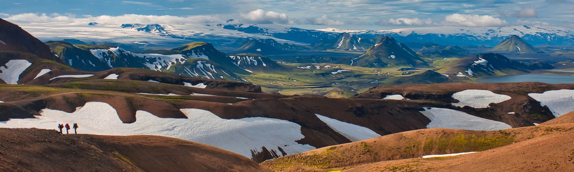
The Laugavegur Trail in Iceland is a famous 55-kilometer (34-mile) trek from Landmannalaugar to Þórsmörk. Known for its stunning variety of landscapes, National Geographic ranks it as one of the world's top trails. You'll see everything from colorful mountains and hot springs to black deserts and green valleys. Starting in the vibrant Landmannalaugar and ending in the glacier-surrounded Þórsmörk (‘Thor’s valley’), it truly shows Iceland's wild and unique nature.
Where is Laugavegur Located, and How Do You Get There?
The hike's starting point, Landmannalaugar, is 182 kilometers (113 miles) away from Reykjavik. You can only get there on mountain roads and only during the summer. If you are wondering how to get to Laugavegur trail, do not worry because it is quite straightforward. From Reykjavik and back, you can catch a bus that's ready for rough roads, or if you're up for it, rent a 4x4 and drive yourself. Remember to book your bus spot in advance, as seats fill up quickly!
How Long is the Laugavegur Trail?
The trail is 35 miles or 55 kilometers long. Most people take4 to 5 days to hike it, but it's all about your pace. Speedy hikers can conquer it in 3 days, while those who like to soak in every view might stretch it to 6 days.
Each part of the trail has its own feel and challenges. The first part, climbing up from Landmannalaugar, can be tough, but it rewards you with amazing views. As you move along the trail, the scenery changes dramatically, from wide-open black sand areas to the glacial mountains of Þórsmörk.
We will talk about the elevation and itinerary in more detail below.
The Laugavegur Trail lasts for 55 km from rugged Landmannalaugar to glacial Þórsmörk, and takes 3-6 days.
10 Reasons To Do Laugavegur Hike
The Laugavegur Trail is a top-rated hiking route known for its stunning scenery and convenient huts and camping facilities.
1. Discover The Unique Icelandic Highlands
The uninhabited wilderness in the interior of Iceland is called the Icelandic Highlands. Endless black deserts, rough volcanic mountain ranges, glistening glaciers, lush geothermal areas. These are just a few faces of the mysterious Highlands that you can see on this trail.
As you hike, you will encounter rough fields of solid lava that stretch for tens of kilometers. These fields are covered with thick green moss and have snow patches here and there. You will see steam rising from the ground and snowy peaks sparkling in the distance. The striking combination of fire and ice will surround you in all directions!
3. Bathe In A Natural Hot Spring
Some of Iceland’s most active volcanoes are close to this trail. The word ‘Laugavegur’ translates as the ‘Hot Spring Route,’ which refers to the impressive geothermal activity in the area. There is a natural hot spring at Landmannalaugar, just where the trail starts. Bathing in this naturally warm water in the middle of nowhere is the experience of a lifetime!
4. Meet New Friends From All Over The World
On a guided tour (or even if you go solo), you will travel with like-minded adventurers from all over the world. Together, you might step out of your comfort zone, share in the challenges and the joy, and develop strong bonds. This is where lifelong experiences are made.
5. Meet Yourself On The Way
The Laugavegur hiking trail is the Arctic version of Camino de Santiago. Hikers on this trail discover that walking in the wilderness, facing the elements, and admiring indescribable natural sights…all lead to a higher level of thinking, another state of mind.
The Laugavegur hiking trail is the Arctic version of Camino de Santiago.
6. Challenge Yourself And Enjoy The Benefits
The Laugavegur hiking trail can be challenging both physically and mentally. Making it your personal mission, you’ll discover more about yourself and improve your strength, resilience, and self-awareness.
7. Have A Compelling Story To Tell
This is a bucket list, a once-in-a-lifetime experience you’ll want to share, whether on your blog, for your grandchildren, on a first date, or around the campfire on your next adventure.
8. Ideal for Solo Travelers
Iceland is one of the safest countries in the world. Its other amazing benefits are that summer nights are completely bright and no dangerous animals live there. This is the main reason why it is one of the top destinations for solo travelers. Venturing into new territory still takes courage, so this hike is a perfect opportunity to test your mettle in a safe environment in Iceland.
9. You Can Continue Towards Glaciers And Volcanoes
One of the most famous volcanic eruptions occurred in 2010 when the Eyjafjallajökull volcano became world-famous. Its two new craters, Magni and Móði, are located on the Fimmvörðuháls trail, which starts in Þórsmörk, where the Laugavegur ends. The Fimmvörðuháls trail leads between three glaciers and two volcanoes and ends at the stunning Skógafoss waterfall. Connecting the two trails, Laugavegur and Fimmvörðuháls, will give you 5 or 6 days of pure adventures!
10. Hike One Of The Best Hiking Trails In The World
Earlier, we mentioned that National Geographic chose the Laugavegur and Fimmvörðuháls trails as one of the world's top 20 best hiking trails. They are definitely the most beautiful hiking trails in Iceland!
Laugavegur Trail Map
4 Day Itinerary of the Laugavegur Trail
About Elevation on the Laugavegur Trail
Elevation plays a big role in this hike, especially on the first day. Starting at 1,706 feet (520 meters), you'll ascend to 3,474 feet (1,060 meters) and then descend to below 2,000 feet (610 meters) at Álftavatn Lake.
The elevation remains fairly consistent until the final day's descent to under 1,000 feet (305 meters). For those extending their hike beyond Thórsmörk to Skógar via Fimmvörðuháls, prepare for a steep climb up to 3,504 feet (1,070 meters) and the descent after that, all within two additional days of hiking.
Laugavegur trail map for 4-day trek.
Day 1: Landmannalaugar to Hrafntinnusker (12 km / 7.5 mi)
Start your Laugavegur trek in Reykjavik and journey to Landmannalaugar, where a scenic hike through colorful fields awaits on the first day.
On the first day of the Laugavegur trek, you'll go on a scenic drive from Reykjavik to Landmannalaugar, which offers early views of the impressive Hekla volcano. Once you reach Landmannalaugar, you'll immediately notice the unique hill peaks in red, green, and caramel shades.
Your hike will start with an uphill walk through the Laugahraun lava field. This area stands out with its black lava rocks and the bright green vegetation and mountains that surround it. During this section, you'll come across Brennisteinsalda, also known as the "Sulphur Wave." It's easy to spot this mountain because of its yellow sulfur deposits, red iron, and green moss set against a blue and black lava background.
As you keep going, you will come across the Graenagil Gorge, a stunning green canyon, and the Storihver hot spring. If you have enough time, it is recommended to take a side trek up the Blahnjukur volcano for panoramic views.
By the end of the day, you get to climb up about 1540 feet (which is around 470 meters), and it usually takes about 4 hours of walking to complete the hike. Although it can be a bit tough, the experience is totally worth it!
The day ends at the first mountain hut in Landmannalaugar. The hut at Hrafntinnusker is set in a remote location with black volcanic slopes and snow-covered peaks. You will be resting at an elevation of 1110 meters, so the views are absolutely stunning!
Day 2: Hrafntinnusker to Álftavatn (12 km / 7.5 mi)
On day two, hike 12 kilometers from Hrafntinnusker to Álftavatn, descending from the high-altitude hut, and conquer the basalt hills beneath Reykjafjoll Mountain.
Today, on the second day of your hike, you'll cover 12 kilometers (7.5 miles) as you move from Hrafntinnusker to Álftavatn, down from the high-altitude hut. Although this section may have some challenges, it's nothing you can't handle as you walk through the basalt hills beneath Reykjafjoll Mountain.
The area around Kaldaklofsfjöll Peak is mostly flat, but you must be careful because of hidden snow bridges over deep gaps. The walk up to the Jökultungur plateau is easy and steady. When you reach the top, you'll be treated to wide views of the area. On clear days, you can even see parts of the Tindfjallajökull, Eyjafjallajökull, and Mýrdalsjökull glaciers!
Coming down from Jökultungur, the path takes you into the Álftavatn Valley. Here, you'll see Lake Álftavatn, surrounded by volcanic mountains and greenery. The way down is a bit rocky at first, but then it becomes an easy walk across a valley floor covered with soft moss and grass.
The highlight of the day is crossing the Grashagakvísl river. You'll pass through chilly but very clean waters from the glacier. From there, the way to the hit is quite easy. When you get to the Álftavatn hut and campsite, you'll have a nice place to rest for the night. The campsite has hot showers to freshen up and relax.
Day 3: Álftavatn to Emstrur (15 km / 9.5 mi)
On day three, hike 15 kilometers from Álftavatn to Emstrur, experiencing Iceland's volcanic terrain and Markarfljótsgljúfur Canyon, ending at Botnar Huts.
On day three, you'll hike from Álftavatn to Emstrur, covering a distance of 15 kilometers (9.5 miles) over about 6 to 7 hours. The day starts with a bit of a challenge: crossing a stream and possibly more as you go.
Your path leads into the Mælifellssandurarea, a huge stretch of volcanic desert. The scenery here is mostly black sand, which is a big change from the green areas you saw before. As you walk through this region, you'll go by two interesting peaks: Mt. Stórasúla, with its green slopes, and Hattafell, known for its flat top. This part of the trek gives you a special look at Iceland's volcanic terrain.
On a clear day, the hike gives you amazing views of the Mýrdalsjökulland Eyjafjallajökullglaciers. These glaciers are important for both their geology and history. Eyjafjallajökull is especially well-known for its 2010 eruption that caused a lot of trouble for air travel. Hidden under Mýrdalsjökull is Katla, one of Iceland's most active volcanoes.
As you get closer to Emstrur, the path leads you to the Markarfljótsgljúfur Canyon, which is technically a detour but totally worth it. This impressive canyon, carved 200 meters deep by the Markarfljót River, shows the incredible power of Iceland's natural forces.
Your day's hike ends in the Emstrur region, where you'll stay for the night in Botnar Huts. This spot is like a green shelter in the middle of black volcanic sands.
Day 4: Emstrur to Þórsmörk (15 km / 9.5 mi)
On the last day, hike 15 kilometers from Emstrur to Þórsmörk, descending 300 meters, with highlights including river crossings and a lush green valley.
On the last day of your trek, you'll travel 15 kilometers (9.5 miles) from Emstrur to Þórsmörk. Walking this distance takes about 6 to 7 hours, and you'll go down 300 meters (985 feet). The day starts with going down to the Syðri-Emstruá River. You'll cross a footbridge over a deep canyon, witnessing a powerful stream below.
Next, the trail takes you up to a plateau above the canyon. If you go to the edge, you'll see where the Syðri-Emstruá and Markarfljót rivers meet. This amazing view is created by water from the Mýrdalsjökull and Eyjafjallajökull glaciers. The path then goes south through the Almenningar hills, turning greener as you go. You'll cross two small ravines, Slyppugiland Bjórgil, each with a stream of drinkable water.
Close to the end of the day, you'll climb up to the top of Kápa, the last steep slope on the trail, and then cross the Þröngá River. This part of the trail is rocky but not too hard. When you reach Þórsmörk, or 'Thor’s Valley,' you'll be in the greenest part of your journey. The valley is full of woods, Hamraskógar, where you can see small trees and a ground covered in wild herbs and flowers. A rare sight in Iceland!
On the last day of your trek, you'll travel 15 kilometers (9.5 miles) from Emstrur to Þórsmörk.
When you reach Þórsmörk, you have a few accommodation options, including the hut and campsite at Langidalur. For those continuing on the Fimmvörðuháls trail, the small Baldvinsskáli hut is about 2.5 miles along the route. Alternatively, there are Volcano Huts with a sauna, a hot pool, and a restaurant for a more luxurious end to the trek.
That’s the end of the trail in Þórsmörk, which is a big achievement! With its special climate and thick birch forest, this valley is very differentfrom the landscapes you've seen in the last few days. Take some time to celebrate your accomplishment in this beautiful place. Then, on your way back to Reykjavik, don't miss stopping at the stunning Seljalandsfoss waterfall. It's the perfect location to wrap up your extraordinary trip!
Optional extension: Fimmvörðuháls Trail
If you want to add more adventure to your Laugavegur Trail hike, try the Fimmvörðuháls Trail. It's an extra 25 km (15.5 miles) and takes about 1-2 days. The trail starts at Thórsmörk, the end of the Laugavegur Trail, and ends in Skógar on Iceland's south coast. You'll climb up to 1,070 meters (3,504 feet) at the Fimmvörðuháls pass.
The path goes along the southern side of the Eyjafjallajökull volcano through active volcanic areas. It's tougher than the main trail, with steep, rocky climbs. A big highlight is the Skógafoss Waterfall, a famous Icelandic sight. Depending on how fast you hike, you can stay in mountain huts or camp.
When is the Laugavegur Trail Open?
Thinking about hitting the Laugavegur Trail? It's typically open from mid-June to early September. These dates can vary slightly, as they're at the mercy of Iceland's unpredictable weather. Snow and trail conditions are the big deciders here, so checking with local authorities for the exact opening dates each year is wise. This way, you're all set for your trek without any surprises.
Planning to hike the Laugavegur Trail? It's usually accessible from mid-June to early September.
Best Time of the Year to Go
The prime time to explore the Laugavegur Trail is betweenlate June and August. This period offers the best of the Icelandic summer – milder weather and extended daylight hours. July and August are particularly popular for their warmer temperatures and vibrant landscapes. If you prefer a quieter trail, consider late June or early September, but be prepared for more unstable weather conditions.
What to Pack for the Laugavegur Trail
Packing right is key for the Laugavegur Trail. Here’s what you should bring:
Weather-Ready Clothing. Pack waterproof and windproof jackets and pants, along with thermal layers and moisture-wicking undergarments.
Durable Hiking Boots. Ensure they’re waterproof and well-worn.
Reliable Backpack. Choose a comfortable backpack equipped with a rain cover.
Sleeping Bag. Necessary for a good night's sleep, whether in huts or tents.
Food and Water. Bring enough supplies, including snacks and a refillable water bottle.
Navigation Tools. A map, compass, and GPS device are crucial, especially in foggy conditions.
First Aid Kit. Include basic supplies and any personal medications.
Camping Essentials. Bring a sturdy tent, sleeping pad, and cooking gear if you're camping.
The Laugavegur Trail offers huts managed by the Icelandic Touring Association (FÍ) for basic accommodations.
The Laugavegur Trail offers both huts and camping options. The huts, managed by the Icelandic Touring Association (FÍ), provide basic accommodations and are located at key points like Landmannalaugar, Hrafntinnusker, Álftavatn, and more. Book these in advance, especially during peak season.
For campers, there are special spots near each hut to set up your tent, and you can use basic facilities there. Camping lets you plan as you go, but you'll need to carry more things with you.
The cost of camping is between 2,200 ISK and 2,300 ISK while staying in huts is around 13,000 kr. Campers can't use the hut kitchens but can access bathrooms, drinking water, and outdoor tables. Showers cost 900 ISK for 5 minutes, but none are at Hrafntinnusker or Baldvinsskali.
Note that wild camping along the Laugavegur Trail is not permitted.
Hiking the Laugavegur Trail: Guided Tour vs. Solo
When planning your Laugavegur Trail trip, one of the key decisions is whether to go on this journey solo or join a guided tour. While both options have their pluses, there are a few important reasons to consider a guided tour.
Guides help to keep your trip eco-friendly to preserve the trail for future hikers.
Reasons to Choose a Guided Tour
Hiking and trekking guides are deeply knowledgeableabout Iceland's landscapes and culture.
Trained guides know how to behave in unpredictable weather and tough terrain, ensuring your safety.
Enjoy a stress-free hike as we handle all logistics, from accommodation to meal planning.
Being part of a group can be reassuring. You'll have companions to share the experience with, which can be comforting if you're new to hiking.
Guides help to keep your trip eco-friendly to preserve the trail for future hikers.
A guided tour is a great chance to learn hiking skills and techniques. Guides can offer tips on everything from proper hiking form to efficient packing.
Hiking Solo
Hiking the Laugavegur Trail solo is possible and can be a rewarding experience for well-prepared, experienced hikers. It offers flexibility and a personal connection with nature. However, it requires a solid background in preparation, including route planning, accommodation booking, and readiness for emergency situations.
Guided Tours
Whether you're an experienced hiker or new to long hikes, our guided tours are a great way to conquer the Laugavegur Trail. We take care of everything – from expert tips to safety and the trip details. You can focus on walking and enjoy the trail's beauty, knowing you're in good hands.
How long does it take to hike the Laugavegur trail?
Most hikers complete the Laugavegur Trail without the Fimmvörðuháls extension in 4 to 5 days. The trail is approximately 55 kilometers (34 miles) long. The length of the trip can vary based on your pace, the weather, and how long you stay at each place.
How difficult is the Laugavegur trail?
The Laugavegur Trail is considered moderately difficult. It involves varied terrain, like steep ascents and descents, river crossings, and potentially challenging weather conditions. Hikers need to be in good physical shape and have some experience in long-distance trekking.
Can you hike the Laugavegur trail without a guide?
If you're an experienced hikerwho is comfortable with changing weather conditions and finding your way, you can hike the Laugavegur Trail without a guide. The trail is popular and marked well, so it's easy to follow. However, if you're less experienced, you will need the knowledge and safety that a guided tour provides.
How far are the huts on the Laugavegur trail?
The huts along the Laugavegur Trail are spaced out, typically a day's hike apart. The average distance between huts is about 12 kilometers (7.5 miles), which can vary.
How many people hike the Laugavegur trail?
The Laugavegur Trail is one of Iceland's most popular hiking trails. Between75,000 and 100,000 people trek it each year, especially during the peak months of July and August.
When does the Laugavegur Trail open?
The Laugavegur Trail typically opens from mid-June to early September. These dates change based on weather conditions, particularly snow levels and trail safety. It's important to check current conditions and opening dates before planning your hike.
Should I camp or use the Laugavegur hiking trail huts?
Choose between camping and huts based on your preference for comfort and adventure. Huts offer more comfort but require advance booking and are costly. Camping is flexible but means carrying more gear.
What should I pack for the Laugavegur trail?
Pack lightweight, weather-resistant clothing, sturdy hiking boots, a sleeping bag, and a reliable backpack. Don't forget essentials like food, water, navigation tools, and a first aid kit. Check out our full Laugavegur packing guide for a detailed packing list.