Anhelina is a cat mom with a passion for cycling, adventure, and writing. She spends her days inspiring and educating other travelers through her stories by going down rabbit holes of research.
Looking to explore Iceland's incredible landscapes? Discover our expert guide to the best hikes in Iceland with maps to get you started!
Hikers of all levels, from novice to expert, flock to Iceland to experience the unusual landscapes shaped by volcanic activity and other forces of nature. Often referred to as ‘hikers paradise,’ the assortment of hiking trails in Iceland vary from dramatic coastlines and expansive valleys to active volcanoes and snow-capped mountains.
Man hiking in Icelandic canyons
Aside from the astounding scenery in Iceland, there are also many other benefits tohiking in the land of fire and ice, including the ability to stop almost anywhere and enjoy a soak in a hot spring and the cool climate, which means even in the summer, it’s never too hot for hiking.
Knowing what beautiful hiking trails to choose for your Iceland itinerary can be challenging, with so much untamed wilderness to explore. That is why we’ve put together the ultimate hiking locations and even added maps for some of the best, so you can start planning your trip immediately!
A Guide to Hiking in Iceland
Each region of this country offers visitors something different and unique. There are some fantastic hiking spots surprisingly close to the capital. Many hiking trails are easily accessible from the main road. There are beautiful trekking routes off the beaten path, far away from the populated areas.
Whether you fancy climbing ice walls and glaciers, reaching the summits of tall mountain tops and volcanoes, exploring thrilling waterfalls and hot springs, or backpacking across Iceland’s national parks, many options are available for every kind of adventurer.
A road sign on Landmannalaugar trail
Aside from giving you a lot of alternatives when it comes to sightseeing, the variety of trails to choose from will provide a fantastic hiking adventure no matter your fitness level.
Whether you are an experienced hiker or just starting, you will find a suitable experience in the following list of the best hikes in Iceland that we have put together for you. Enjoy your walk!
When Is the Best Time to Hike in Iceland?
One of the most common questions regarding hiking in Iceland is, when is thebest time to do it?
The Main Hiking Season: Summer
Ultimately, the summer months – June, July, and August – are the best for hiking in Iceland. These are the warmest, the driest, and the least stormy months, making summer the safest and the most comfortable time for hiking. The temperatures range between 10-20°C (50-68°F), and the average wind speed, precipitation, and storm frequency are lower than at any other time of the year.
The landscape blooms in its full glory, sheep freely wander through the green pastures, vivid Arctic flowers grow everywhere, mosses and birch forests thrive, and loud bird chatter fills the air with life. Locals and foreign visitors spread out to the greenery to explore Iceland’s hidden beauties and enjoy the gifts of the summer and the midnight sun. Real adventurers will leave the beaten path and wander into the Highlands to follow Iceland’s best hiking and trekking routes.
These trails are open only for a limited period during the short summer months. TheIcelandic Highlands are only accessible for hikers between mid-June and early September, while the world-famous Laugavegur is best to complete from July to late August. The remoteHornstrandir Nature Reserve is also accessible from mid-June to August 20. These areas are the most pristine hiking sites in Iceland.
Hiking on Fimmvörðuháls trail
Hiking in the Off-Season
The edges of the season, from May to mid-June and from late August to mid-October, are pretty unpredictable. The temperatures are usually afew degrees lower than in summer, and the weather is much more erratic. Both spring and autumn can be stormy and windy or beautifully sunny and calm, but no one can know this in advance. Every year is different.
The landscape is usually golden brown all over the country, if not white. In May and June, there is no darkness at night. In May, the endless sunsets and sunrises start to kick in. However, the nights are dark in September, and the Northern Lights may appear in the sky.
The accessibility of the trails depends highly on the actual weather conditions, the area, and the type of terrain you would like to hike.
Even if the weather is excellent throughout the country, the Highlands are still inaccessible in May due to bad road conditions and snow. However, some shorter and less remote trails, such as the Reykjadalur Hot Spring Hike, the Glymur Waterfall Hike, or the Thorsmörk Volcano Hike, can be completed in spring and autumn.
September is usually rainy and stormy, but it can sometimes be nice and sunny, too. October is considered the beginning of the winter; this is when the first snow falls in the lower altitudes, while the Highlands will already be covered by thick snow.
Scenery of Thorsmork mountain ridge, Iceland
Hiking in Winter
Iceland, of course, is famed for its long winters. The winter season, however, can be one of the best times to visit. The country is at its best when twinkling in the snow and shining under the Northern Lights. And, despite what you may think, Iceland is not that cold in the winter, with Reykjavík experiencing an average temperature of 0°C (32°F) during winter. The average temperature in the mountains is much lower, of course.
Winter is not the best time for longer hikes. The daylight lasts only 3-6 hours, and most of the hiking trails are not accessible at all. However, some low-altitude walks, such as the famous Reykjadalur Hot Spring Hike, are walkable all year round. Even hiking these shorter tails requires good preparation.
It is necessary to research the weather, the trailconditions, and the possibility of avalanches before heading out. Hiking spikes or crampons are a must. For the best experience and safety, join a guided hiking tour. Once you have packed the right equipment, enough layers, and provisions, hiking in winter in Iceland is a thoroughly enjoyable experience.
Man looking over the snow-covered mountains
Tips for Hiking in Iceland
Hiking in Iceland is an activity that is full of adventure and wonder. Still, there are many things to consider when exploring the island's cold, sometimes remote, isolated trails and routes. To make the most of your experience, here are some top tips:
Always keep an eye on the changeable, unpredictable weather conditions that can make your hike more difficult and risky
Take plenty of water to keep yourself hydrated
Plan your route and check for alerts or warnings onSafe.is
Wear appropriate clothing and footwear, multiple layers and waterproofs are recommended
Make sure you are equipped with a torch and plan your time to make sure you can get to your destination before night falls.
Suppose you’re keen to take advantage of the best trails in Iceland but aren’t sure about heading out on your own. In that case, we have a variety of hiking andtrekking tours available whereby you can benefit from the expertise of a friendly, local guide.
Iceland’s Best Hiking Routes
Each year, thousands of visitors travel to Iceland to experience and enjoy the country’s exciting hiking routes, some of which deservedly appear on lists of the best hikes in the world. Gifted with a highly varied landscape and awe-inspiring natural wonders, Iceland is one of the best places in the world for hikers and explorers.
1. Glymur Waterfall Hike
Length: 6.9 km (4.3 miles) | Level: Moderate | Route Type: Out & back | Duration: 3 hours
The Glymur Waterfall Hike takes you to the second-highest waterfall in Iceland at a height of 119 meters (390 feet). Thisstunning waterfall hidden away at the end of Hvalfjörður, the whale fjord, is a treasure that can only be accessed on foot, which means ahike here is necessary to reach it.
Hvalfjörður, the whale fjord, is about an hour’s drive from Reykjavík. The Glymur hiking path takes you through a picturesque cave, follows a steep gorge, and is beautifully exposed with thrilling viewpoints of the breathtaking canyon and waterfall.
The hike begins with a relatively flat walk to the Botnsá River, a serene water body setting the tone for the natural beauty. As you approach the river, you'll pass through a small cave. The trail then follows the river upstream towards the waterfall, a path that gradually ascends, offering increasingly impressive views of the waterfall and the surrounding valley.
Hvalfjordur, Iceland
One of the unique features of this hike is the river crossings. During the summer months, a log is placed to assist hikers across the Botnsá River. However, during the rest of the year, when snow and ice cover the ground, the record is removed, making the hike more challenging and suitable only for experienced hikers.
As you ascend, the trail offers several points from where you can admire the Glymur waterfall and the entire valley. The higher you climb, the more breathtaking the view becomes. The trail also takes you close to the cliff's edge, offering a thrilling experience for those who don't mind heights.
At the highest viewpoint, you can choose to return to the way you came or cross the river and hike down the other side for a different perspective. This makes the Glymur waterfall hike one of the best hikes in Iceland. You will not be disappointed, for sure!
Remember, the best time to undertake this hike is June through September, when the weather conditions are most favorable.
The geothermal valley of Reykjadalur, only a 40-minute drive from the capital, is a region of tranquil natural beauty and exciting geothermal activity. Although short, the hike to Reykjadalur Valley undoubtedly deserves a place at the top due to its bubbling springs, rising steam, and boreholes, which create a landscape of wonder.
You can explore the “steam valley” at your own pace and witness the hot water flow down the slopes of the Hengill volcanic mountain range. The trek here is a simple route from the car park, and you shouldalways stay on the pathsto avoid the bubbling pools of water.
In a valley between the mountains in the middle of nowhere is a steaming warm river where the water temperature is ideal for enjoying a relaxing bath. There is plenty of space, so even if the place is quite popular, it is still worth a visit! You should also allow time to admire the Djúpagilsfoss Waterfall and the picturesque gorge that surrounds it.
Hiking in Reykjadalur is a great day trip for anyone, whether you are a true hiker or just keen on escaping the hustle and bustle of city life.
The Skógafoss Waterfall Way, also known as the Skógá Trail or Waterfall Way, is a hidden gem among the best hikes in Iceland. Starting at the iconic Skógafoss waterfall, the trail follows the Skógá River upstream for 8 km (5 miles). As you traverse this verdant landscape, you'll encounter over 20 waterfalls, dramatic canyons, and distant views of glacier-capped volcanoes. It's a breathtaking journey that could quickly become one of the highlights of your visit to Iceland.
The trail begins at Skógafoss, one of Iceland's most famous waterfalls. The initial part of the hike involves climbing a giant staircase next to Skógafoss. Once at the top, you'll be rewarded with a stunning view and the start of a beautiful walk. As you move further from Skógafoss, the crowds thin out, and you'll find yourself surrounded by the serene beauty of the Icelandic landscape.
The first section of the trail, leading to High Peaks and Cascading Falls, is a steady uphill walk. You'll see a few small canyons and glimpse the glaciers Eyjafjallajökull and Mýrdalsjökull in the distance. The landscape is vibrantly green during the summer months, creating a stark contrast against the blue sky and the white peaks of the glaciers.
As you continue on the trail, you'll reach the Subtle Falls, a beautiful, double-tiered waterfall tucked away in a canyon. This is near the trail's end, so you'll have to hike almost the entire Waterfall Way to see it. The turn-around point is the bridge over the Skógá River. The landscape changes here, with the green vegetation fading away, replaced with a gray, rocky terrain.
The return journey to Skógafoss is an overall downhill walk, a pleasant stroll with repeat views of the waterfalls. Each step brings a new perspective, a new waterfall, and a new piece of Iceland's stunning landscape.
Hike from Skógafoss waterfall alongside the Skóga River in the south of Iceland
4. New Volcano Eruption Site
Length: 20 km (12.4 miles) | Level: Moderate | Route Type: Out & back | Duration: 9 hours
If you're seeking a once-in-a-lifetime encounter with nature's raw power, lace up your hiking boots and venture toward the site of the newest volcanic eruption in 2023 on the Reykjanes Peninsula. This captivating hike offers the thrilling opportunity to witness the planet's evolution firsthand.
Adding to the recent geological drama, 2023 marked thethird consecutive year of volcanic eruptions on the Reykjanes Peninsula. After the stirring events at Fagradalsfjall in 2021 and Meradalir in 2022, the earth roared once more on July 10th, 2023, birthing another volcanic marvel called Litli-Hrútur. You can explore the site of this latest eruption, witnessing firsthand the breathtaking spectacle of Iceland's newest member of its volcanic family!
The trail around the volcano boasts fresh lava formations, volcanic craters, and an experience like no other. You can also hike around the older lava fields and volcanic fissures from the previous years’ eruptions.
Volcanic eruption in Iceland
Remember that conditions can change rapidly, and trails at the eruption site may be altered or closed at short notice for safety reasons. Always follow local advice, respect any warning signs and closures, and ensure you are adequately prepared with the proper clothing, equipment, and provisions for your hike.
Also, we recommend visitors to the volcano follow these steps in the area:
Keep your distance, and don't step into the lava from the eruption.
Due to the risk of gas exposure, do not go down into the valleys. Instead, observe the eruption from the hills and mountainsides.
Be aware of the wind direction.
Avoid standing directly against the wind.
Whether you're a seasoned hiker or just starting, the trails around the new eruption site provide an unforgettable adventure. Hiking these trails is more than just a physical activity; it is an encounter with the primal forces of nature.
For those looking for added security and insight, consider joining a guided hiking tour of these volcanic sites. Our hiking tours offer a layer of safety and the opportunity to learn about these landscapes' geological history and significance from expert guides.
Volcanic eruption in Iceland
5. Hornstrandir: Adalvik to Hesteyri
Length: 33.7 km (21 miles) | Level: Hard | Route Type: Out & back | Duration: 10-11 hours
The outstanding Hornstrandir Nature Reserve is Iceland’s most remote hiking area, located in Westfjords.The Westfjords are arguably Iceland’s most remarkable region and one of Europe’s last undisturbed wilderness areas, covering 580 square kilometers (220 square miles). Full of mystery and natural beauty, the Westfjords are begging to be explored and should be at the top of the bucket list when it comes to hikes.
Since Hornstrandir is in the country's least traveled area, there are authentic off-the-beaten road adventures with plenty of fantastic hiking opportunities.
Firstly, you’ll need to take a boat from Ísafjörður to reach the isolated reserve, where you can begin the trail. Yes, Hornstrandir is so remote and isolated that it is only accessible by boat! There are no roads, no infrastructure, no services, and no cell phone reception.
The region is only accessible during the mid-summer period, making hiking only possible from late June to mid-August. Even in those months, the nature reserve is by far the least frequented hiking area in Iceland. One can trek for days in Hornstrandir without seeing a single person!
Hiker in Hornstrandir, Wetman Islands
You’ll navigate black pebbly coastlines, steamy hills, and muddy paths - you may even be lucky enough to stumble across wildlife. The nature reserve is home to some of Europe’s most immense and thrilling bird cliffs.
The breathtaking natural scenery and Arctic foxes make this area even more special. They are protected and abundant here, so they are not shy. Sometimes they approach the hikers at a very close range, and they are very curious. Iceland’s only native mammal may be one of the cutest animals on the planet!
There are no huts in the nature reserve, so multi-day hikers must sleep in tents. Anyone traveling here must be self-reliant and fully prepared with enough food, water, high-quality clothing, and camping equipment.
For maximum safety and comfort, we recommend joining guided hiking tours where an experienced local guide will lead you through the most beautiful Iceland hiking site on the remote peninsula. Guided day hikes and multi-day treks depart from Isafjordur during the summer, from mid-June to late August.
If you’re considering challenging yourself to something more strenuous, a6-day Hornstrandir hiking tour is one of the best ways to experience the Westfjords. For tours, take a look at our day trips in the Westfjords.
6. Mount Esja Trail
Length: 6.9 km (4.29 miles) | Level: Moderate | Route Type: Out & back | Duration: 2.5 hours
As one of the most accessible hiking trails from Reykjavik that can be completed in less than a day, theMount Esja hiking trail, shown in the map below, is extremely popular.
The trail begins at the foot of Mount Esja, a prominent mountain range that stands as a backdrop to the city of Reykjavik. The path is approximately 6.9 kilometers (4.29 miles) long and is considered moderate in terms of difficulty. Despite its proximity to the town, the trail offers a genuine wilderness experience, with a diverse range of flora and fauna to be seen along the way.
As you go up the trail, you'll be treated to stunning views of the surrounding landscape. The trail winds up to the top of the Tverfellshorn mountain range, 769 meters (2523 feet). Reaching the summit is a rewarding experience, with panoramic views of Reykjavik and the surrounding countryside.
However, it's important to note that the conditions on the trail can change rapidly, especially during the winter months when the mountain is often covered in snow. During these times, the climb can become extremely dangerous, and additional equipment, such as crampons and an ice axe, may be necessary. Always check the weather forecast and trail conditions before setting out, and be prepared to turn back if conditions become unsafe.
Mount Esja hiking trail in Iceland
7. Brúarfoss Waterfall Hike
Length: 6.5 km (4.1 miles) | Level: Moderate | Route Type: Out & back | Duration: 2.5-3 hours
TheBrúarfoss waterfall is small but mighty, known as Iceland’s bluest waterfall. The Brúarfoss Waterfall Hike is a captivating journey that takes you through some of Iceland's most scenic landscapes. The waterfall's vibrant blue hue, contrasted with the lush greenery of its surroundings, makes it a sight to behold.
The hike to Brúarfoss begins at a parking lot. The trail is relatively flat, making it accessible to hikers of various skill levels. However, the terrain can be uneven and muddy sometimes, so it's essential to come prepared with waterproof hiking boots. Despite these challenges, the trail is well-marked and easy to follow.
The path winds through various landscapes, from open fields to dense forests, offering tranquility and adventure. The sound of the rushing water in the distance is a constant reminder of the spectacular sight that awaits at the trail's end.
One of the highlights of the Brúarfoss Waterfall Hike is the opportunity to spot two other waterfalls: Hlauptungufoss and Miðfoss. Hlauptungufoss boasts cascading waters and surrounding greenery, while Miðfoss, although smaller, is equally captivating with its serene setting.
The Brúarfoss Waterfall Hike is a unique opportunity to immerse yourself in the country's stunning landscapes, witness its vibrant blue waterfall, and explore its diverse flora and fauna.
The Brúarfoss waterfall is a popular stop on the map when hiking in Iceland
8. The Trek to Stórurð from Vatnsskarð
Length: 7.5 km (4.7 miles) | Level: Moderate | Route Type: One way | Duration: 2.5 hours
The trek to Stórurð from Vatnsskarð is a journey that takes you through some of the most enchanting landscapes in Iceland. Nestled below a glacier and to the west of the majestic Dyrfjöll mountains, Stórurð is a hidden gem that offers a unique Iceland hiking experience.
The trail is approximately 7.5 kilometers (4.7 miles) long and is considered moderate in terms of difficulty. It's a one-way route that takes around 2.5 hours, making it a perfect choice for a half-day adventure. The trail is well-marked and easy to follow, but it does involve some uphill walking and navigating through rocky terrains, so a decent level of fitness is required.
The journey begins at Vatnsskarð Pass, where the trail gradually ascends towards the Dyrfjöll mountains. As you hike, you'll pass through a landscape dotted with large tuff boulders, a testament to the area's volcanic history. These boulders and the surrounding green meadows contrast starkly against the backdrop of the glacier and the mountains, making for some truly spectacular views.
One of the trek's highlights is the milky blue ponds you'll encounter. These ponds, filled with glacier meltwater, are truly impressive. Their vibrant blue color stands out against the rugged landscape, and they offer a perfect spot for a break, a picnic, or even a refreshing dip if you're feeling adventurous!
As you continue along the trail, you'll encounter several mystical coves waiting to be explored. These coves, hidden among the boulders and the meadows, add a touch of mystery to the hike and are perfect for those who love to explore off the beaten path.
Trek to Stórurð from Vatnsskarð in Iceland
9. Stuðlagil Canyon
Length: 8 km (5 miles) | Level: Easy | Route Type: Out & back | Duration: 2 hours
Nestled in the heart of the Jökuldalur Valley, the Stuðlagil Canyon is a hidden gem in the Eastern Region of Iceland. Known for its striking basalt columns and the mesmerizing blue-green water that runs through it, the canyon offers a unique Iceland hiking experience that is both accessible and rewarding. While the canyon's North rim can be reached by road, the South rim, often considered the most scenic, is best accessed via a simple hiking trail.
The trail to the South rim of Stuðlagil Canyon is approximately 8.8 kilometers (5.5 miles) long. It's an easy hike, making it suitable for hikers of all levels. The total walk duration is around 2 hours, but this can vary depending on how much time you spend admiring the breathtaking views and taking photos. The route is out-and-back, meaning you'll return the same way you came, giving you a second chance to take in the stunning scenery.
As you approach the canyon, you'll be greeted by towering basalt columns, a geological marvel that uniquely charms the canyon. These columns and the vibrant blue-green water of the Jökla Riverthat flows through the ravine create a picturesque scene that seems straight out of a fairy tale.
One of the hike's highlights is reaching the canyon's South rim. You can enjoy panoramic views of the canyon and its surroundings from here. The idea of the basalt columns from the South rim is awe-inspiring, making the hike well worth the effort. It's a perfect spot to take a break, have a picnic, and immerse yourself in the beauty of nature.
The Stuðlagil Canyon hike allows you to explore one of Iceland's most beautiful natural wonders at your own pace. So, lace up your hiking boots!
View from the bottom of the Stuðlagil Canyon in Iceland
The vast 40,000-square-kilometer deserted wilderness in the country’s interior is called the Icelandic Highlands. This area contains some of the most extraordinary landscapes in Iceland and is home to some of the best hikes in Iceland and the world. For those looking for something unforgettable, choosing any of the trails in this area is a complete no-brainer for those looking for something exceptional.
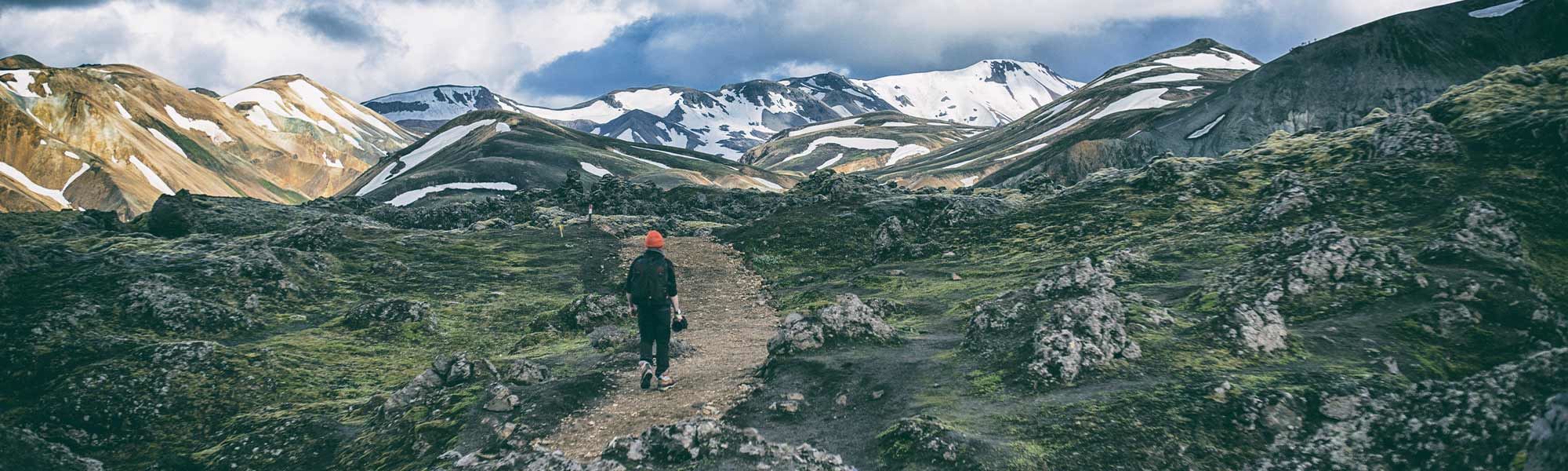
The country’s premier hiking destination, Landmannalaugar, is in the Southern Highlands. This site is famous for its incredibly colorful landscapes, thanks to the multi-colored rhyolite mountains, moss-covered slopes, and geothermal valleys.
The name directly translates to the “Pools of the People” and was initially used by settlers as a bathing area. Known for its mind-blowing natural hot pool and exciting mountainous terrain, Landmannalaugar is a haven for hikers who enjoy ever-changing scenery and unique geographical features.
We even created the designated Landmannalaugar Day Hike that takes you through the Laugahraun lava field up to Mt. Brennisteinsalda, a multi-colored peak and the most characteristic mountain in the region. You will also walk down the surreal Graenagil Gorge, made of unbelievably green rocks.
Then, after climbing the volcanoes of Brennisteinsalda and Blahnukur you will reach the summit of Suðuhámur, another colorful rhyolite mountain. Wander across Vondugil Canyon, hike through the Laugahraun lava field, and bathe in a hot spring while this extraordinary place enchants you.
For those who want to make the most of their visit to the area, we highly recommend spending a few days in Landmannalaugar. Hike past stunning Lake Frostastaðavatn and visit Ljótipollur, an impressive red volcanic crater filled with ocean-blue water.
Ready for a color-filled adventure? Trek through rainbow mountains, explore geothermal valleys, and end the day with a splash in a hot spring - it's Iceland like you've never seen before!
11. The Laugavegur Trek
Length: 54.7 km (34 miles) | Level: Moderate | Route Type: One-way | Duration: 3-4 days
Landmannalaugar is also the base for the famously beautifulLaugavegur Trek, listed as one of the world’s best hiking trails by National Geographic. The Laugavegur Trail leads 34 mi. (54 km) south through some of the most exquisite parts of the Icelandic wilderness.
Laugavegur allows you to experience all beauty ofLandmannalaugar, the location in which the trail begins. Not only will you be immersed amongst the famous rainbow mountains, but you will also be able to admire the blackened ash desert of Mælifellssandur, the geothermal activity in Stórihver and the Markarfljótsgljúfur canyon.
Hikers also walk among the rainbow-colored mountains of the pristine Fjallabak Nature Reserve. They also cross steaming ground, hot springs, sparkling obsidian fields, black deserts, oddly-shaped mountains, deep canyons, and unbridged rivers.
The 4-day Laugavegur hike ends in the lush birch forest of a fertile valley, framed by three glaciers and the moss-covered ridges of the surrounding mountains. This vibrantly green valley, called Þórsmörk or Thorsmork, is one of the locals’ favorite areas for hiking and camping.
The Laugavegur is accessible from late June to early September every year. Four huts along the way are spaced a few hour’s hike apart. Out of season, the huts are closed, and it’s not possible to hike in the area.
If you’re looking to explore the best hikes in Iceland, this trek should be at the top of your bucket list!
Signpost is providing directions in Laugavegur, Iceland
Situated in Iceland’s Southern Highlands, Thorsmörk Valleyis nestled between three glaciers: Tindfjallajökull, Mýrdalsjokull, and the world-famous volcano-glacier, Eyjafjallajökull. Named after the Norse god Thor, the valley boasts many hiking options.
The area offers breathtaking views of jagged, mossy slopes and tapered valleys with sparkling glacier rivers sneaking through them. Thorsmörk is filled with rich birch forests and has a unique microclimate that is somewhat warmer than the surrounding areas.
A fantastic network of hiking trails in the area provides fabulous hikes at various lengths and levels of difficulty. Here are some details about the most popular routes:
Valahnúkur Mountain Loop is a 6.2-mile (approximately 10 kilometers) loop trail near Skógar, Southern Iceland. It's generally considered a moderately challenging route and takes 3 hours to complete.
Thorsmork Volcano Hike: This trail is more challenging and longer than other Thorsmork hikes. It covers a distance of approximately 10 kilometers (6.2 miles) and takes around 4-5 hours to complete.
Laugavegur: This trail is one of the most famous in Iceland, stretching over 55 kilometers (34 miles). It's a challenging trail that typically takes around 3 days to complete. The path is open from mid-July to mid-September.
Volcano Huts to Langidalur: This is a shorter hike, taking about 30 minutes to complete. From Langidalur to Básar Huts is another 30-minute hike via the moveable walkway over the Krossá River.
Thorsmork volcano hike
Our all-time favorite, though, is the Thorsmork Volcano Hike, a full-day tour, including transportation, lasting between 12-14 hours. The hike is approximately 8-10 km (4.97 - 6.21 mi) (around 3-4 hours), with an elevation gain of around 400 meters. This is a moderately challenging hike, but the breathtaking views and unique landscapes make it worth every step.
Along the planned route, you will climb steep hills and traverse deserted plateaus before climbing up to the freshly formed volcanic craters Magni and Modi, named after the children of Thor. These craters were formed in 2010 during the notorious Eyjafjallajökull eruption.
The view from here may be the most beautiful you can find in the entire country! In good weather, you can see up to 100 kilometers (62 miles) into the heart of the Icelandic Highlands!
The trail leads up to the Fimmvörduháls eruption pass and then descends into the vibrant valley of Thorsmörk. After the long hike, on the way back to the city, you will visit the majestic Seljalandsfoss, the 60-meter (196-foot) tall waterfall you can walk behind. If you're not prepared for hiking adventure, join our Super Jeep tour to Thórsmörk.
13. The Fimmvörðuháls Trek
Rainbow appearing over the valley of Fimmvorduhals trail
The 25-kilometer (15.5 miles) long Fimmvörðuháls Trail is Iceland’s second most popular hike. It can be started either in Skógar, from the top of the 60-meter (196-foot) high Skógafoss Waterfall, or in Thorsmörk and ending at Skógafoss.
Most hikers complete this trek in two days, spending the night in the mountain hut on the trail. If started at Skógafoss, the path leads along the Skógá River, with an uncountable number (as far as we know, at least 26!) of waterfallslining the path along the way!
But the Fimmvörðuháls Trek is not just about waterfalls. It's a journey through various unique landscapes, including two glaciers and a volcano. The trail is a leisurely uphill climb, with plenty of places to stop for water and to take in the breathtaking views.
The Fimmvörðuháls Trek is situated between the Eyjafjallajokull and Myrdalsjokull Glaciers in Southwest Iceland, offering spectacular views of natural wonders such as waterfalls, craters, canyons, and glaciers. The maximum elevation on the hike is 1068 meters (3503 feet), adding a challenging but rewarding aspect to the trek.
The trail is also known for its lunar-like rocky and lava landscape, steep hills, and pure water that you can enjoy along the way. The lava fields you'll traverse are a testament to the country's volcanic activity - the lava takes years to cool thoroughly, creating an otherworldly terrain unique to Iceland.
Please note that the trail is only open during June, July, and August due to weather conditions. This hike will leave you with unforgettable memories and a deep appreciation for the raw beauty of Iceland's natural landscapes!
14. The Laugavegur and Fimmvörðuháls Combined Trek
Thanks to their fortunate location, two of Iceland’s most famous treks can be combined into one of the best hikes in Iceland. The ultimate Laugavegur-Fimmvörðuháls Trekstarts with the Laugavegur Trail in Landmannalaugar. The path then leads to the Fimmvörðuháls Trail in Thorsmörk, crossing the Icelandic Highlands in a combined trek that is 77 kilometers (47.8 miles) long.
Imagine trekking through some of the most breathtaking landscapes you've ever seen across a tapestry of awe-inspiring sights only Iceland can offer. That's what awaits you on the combined Laugavegur and Fimmvörðuháls Trek, a 77-kilometer (47.8 miles) journey that mashes up two of Iceland’s most iconic hiking trails into a six-day adventure you won't forget.
Your journey starts with the Laugavegur Trail in the stunning geothermal area of Landmannalaugar. Prepare to be awed by vibrant rhyolite mountains, steaming hot springs, and vast lava fields. From there, you'll continue to the mystical ThorsmörkValley, trekking along the FimmvörðuhálsTrail. This part of the hike takes you through lush forests, deep canyons, and right between the famous Eyjafjallajökull and Mýrdalsjökull glaciers.
A real plus of this epic hike is the possibility of seeing some of thenewest landscapes on Earth, formed by the 2010 eruption of Eyjafjallajökull. Moreover, you can feel the excitement and pure joy of trekking through the Icelandic highlands' untouched wilderness.
To make the most of this adventure and soak in the magnificent surroundings, we recommend checking out the 6-day Laugavegur Trekking Tour. With knowledgeable guides, comfortable mountain huts for accommodation, and meals provided, all you have to do is lace up your boots and hit the trail!
15. Kerlingarfjöll Mountain Range
Scenery of Kerlingarfjoll mountain range
Length: 8 kilometers (5 miles) | Level: Moderate | Route Type: Out & back | Duration: 9 hours
Stepping into the Kerlingarfjöll Mountain Range feels like stepping into a painter's palette. One of Iceland's most rewarding hiking destinations, this captivating expanse enthralls with its vibrant rhyolite mountains and geothermal springs. For those ready to explore the heart of Iceland's wilderness, a journey into the 10,000-year-old mountain range is a must.
An integral part of the Kerlingarfjöll experience is visiting Hveradallir, known as ‘the Valley of Hot Springs.’ It's one of the largest geothermal valleys in Iceland, a land of bubbling mud pots, steaming vents, and azure hot springs.
The Valley lets you visually indulge in the geothermal beauty and invites you to immerse yourself in it literally. Some of these springs are perfect for a rejuvenating dip, although others, with their scorching temperatures, are best admired from a safe distance.
For an enriching and seamless experience, consider joining the Kerlingarfjöll Hiking Tour with experienced guides leading the way and providing fascinating insights about the area's geology, flora, and fauna.
You'll navigate the terrain, revel in the mountain range's magnificent hues—burnt orange to pastel pink—and witness the awe-inspiring geothermal activity. Moreover, our hiking tours ensure your safety, allow you to meet fellow hiking enthusiasts, and eliminate the hassle of route planning and navigation.
16. Snæfellsjökull Glacier Summit Hike
Snaefellsjokull glacier, Iceland
Length: 7-8 kilometers (4.3-5 miles) | Level: Challenging | Route Type: Out & back | Duration: 6-8 hours
Famously used as the setting for Jules Verne’s epic science fiction novelJourney to the Center of the Earth, the mystical Snæfellsjökull glacier-volcano is one of Iceland's most popular tourist attractions.
If you want an icy challenge, love the Snæfellsjökull summit hike! It is one of the best day treks you can do in Iceland. After arriving at the base camp, you will hike over lava and volcanic rocks before tackling the glacier. As you climb higher and higher, snow and ice will become more dominant, so you will need crampons to complete the climb.
From the top, the view is breathtaking. You can see theSnæfellsnes Peninsula from above and across the enormous Faxaflói Bay in good weather. You may even see Reykjavík!
The summit of the glacier reaches a height of 1,446 meters (4,744 feet), with the entire hike only being 7-8 kilometers (4.3-5 miles) long. It is a challenging hike, ranging from 6 to 9 out of 10 in difficulty, depending on the season and the weather conditions. Climbing up to a glacier requires professional guidance and equipment, so join a safe guided hiking tour instead of trying alone.
Conclusion
In conclusion, Iceland is a destination that is, in many ways, unmatched. Its vast array of landscapes, forged by powerful natural forces, presents opportunities for truly epic adventures.
Each trail in Iceland has unique charm and challenges, making every hike a different experience. Best walks in Iceland provide an immersive way to appreciate its extraordinary biodiversity and to witness firsthand the dynamic forces that shape our planet.
As you lace up your hiking boots and prepare to venture into Iceland's wilderness, remember to tread lightly and leave no trace. Embrace the solitude and tranquility these trails offer and renew yourself with the pure, rugged beauty surrounding you. It's not just about reaching the destination; it's about enjoying every step in these magnificent landscapes. Happy hiking!
Remember, these trails arejust the start. There is so much more to explore in this phenomenal country. So, keep your map close and your spirit of adventure closer. There's always another trail waiting in Iceland - ready to take you on your next unforgettable journey.